I’m unsure how Whiskey River was named, but it’s a cool one. This is an advanced run on Peak 7 that can lead you to The Dunes, Xanadu, or Delirium, which will take you to Peak 6 base. It’s a wide open space above the tree-line and it’s a fun way to travel across the five peaks of Breckenridge.
Map of Breckenridge’s Peak 7
Illinois Gulch
The Illinois Gulch District, considered part of the Breckenridge District by Vanderwilt (1947), initially saw hand-worked placer mining as described by Ransome (1911). Hydraulic mining later created a large pit in the area. Parker (1974) mentions a bedrock shaft started in 1898, but otherwise, only placer mining activities are noted. The Breckenridge Troll, located by the Stephen C. West Ice Arena parking lot, is the start of the trail that travels up Illinois Gulch. If you’re visiting in summer, it’s a beautiful area to explore on foot.
Puzzle Mine in Illinois Gulch, southeast of Breckenridge: The Puzzle Mine workings in Illinois Gulch (Illinois Park), southeast of Breckenridge, Colorado. The small railroad trestle or bridge uphill from the mine was located between Hookeye Curve and the Gold Pan trestle. Original creator: 1920–1929 (Creation); Sayre, Robert H.. Robert H. Sayre Collection. Breckenridge History, Colorado.
Railway snow shed in Illinois Park near Breckenridge: Narrow gauge railroad and snow shed over the tracks at Hook Eye Curve in Illinois Park near Breckenridge, Colorado. Original creator: circa 1880s-1903 (Creation); Westerman, Otto. J. Frank Willis Photograph Album. Breckenridge History, Colorado.
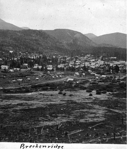
Breckenridge: View of Breckenridge, Colorado, looking northeast shows frame or log dwellings and commercial buildings, including the Catholic Church, and the Gardner residence. Landmarks include Barney Ford Hill, Illinois Gulch, and the grade of the South Park Railroad. Original creator: 1881; Unidentified. Denver Public Library Special Collections, X-1948.
Group portrait of men at the Ouray Mine site in Illinois Gulch near Breckenridge: Mine workers sit or stand by a log stockpile for a group portrait at the Ouray Mine site in Illinois Gulch, east of Breckenridge, Colorado. Behind them is a wood frame building or sawmill. Handwritten on the reverse: “Ouray Mine, Breckenridge.” Original creator: Undated (Creation); Unidentified. Agnes Miner Collection; Gift, Colorado Springs Ghost Town Club. Breckenridge History, Colorado.
View of the railroad trestle and railway tracks on Barney Ford Hill in Illinois Park: View looking northwest towards the Tenmile Range with Illinois Gulch (Illinois Park) in the foreground. The Gold Pan trestle can be seen with the railway line curving around Barney Ford Hill. The Dunkin Mine is on the right. Southeast of Breckenridge, Colorado. Original creator: 1920–1929 (Creation); Sayre, Robert H. Robert H. Sayre Collection. Breckenridge History, Colorado.
Washington Mine [stamp mill]: View of the Washington Mine stamp mill in Illinois Gulch near Breckenridge (Summit County), Colorado. Original creator: [1904?]; Unidentified. Denver Public Library Special Collections, X-62410.
A modern touch
At Wedgewood Lodge, we want to give you a distinctive look into the past history of Breckenridge. Each photo in your historical gallery is unique to your stay and took countless hours to curate. There are stories to tell about Breckenridge and Summit County today as well, and the following photos have been shot by Julia Anna Moore.
Winter 2010
From aerial imagery, you can see the vast expanse of the White River National Forest. Can you point out Breckenridge and Copper Mountain?
From aerial imagery, you can see the vast expanse of the White River National Forest. Can you point out Breckenridge and Copper Mountain?
Summer 2020
In the midst of the pandemic, historic wildfires hit the state of Colorado. Most of my photos during my short walk on Boreas Pass had a hazy red undertone, representative of how my lungs felt even just going a short distance. The air quality was terrible, I’m surprised you could even see these mountains at all.
Duo of the Colorado Rockies framed by Evergreens. You can see the haziness as these photos were taken during the historic 2020 wildfires.
Duo of the Colorado Rockies framed by Evergreens. You can see the haziness as these photos were taken during the historic 2020 wildfires.
More hazy photos of the landscape on fire.
More hazy photos of the landscape on fire.
More hazy photos of the landscape on fire.
More hazy photos of the landscape on fire.
More hazy photos of the landscape on fire.
Summer 2022
Storms in Summit County roll in like clock work during the summertime, so you better do all your fun outdoor activities before lunch. Sometimes the rain blows over quickly, sometimes it lasts until sunset, creating a beautiful pattern in the sky.
The sun sets in July after a thunderstorm kissing Bald Mountain with alpenglow.
The sun sets in July after a thunderstorm kissing Bald Mountain with alpenglow.
The sun sets in July after a thunderstorm kissing Bald Mountain with alpenglow.
The mountains below are some of the same mountains you saw in some of my above photos from the 2020 wildfires. Notice the clarity in the air as the sun sets, lighting the mountains up with alpenglow. 2022 was a very wet year, a large contrast from the year of COVID-19.
A panoramic view of the White River National Forest.
Autumn 2022
A small snowstorm turned the peaks white in September, and I ran out of my front door to get the clouds leaving the mountains as the sky cleared. The excitement of ski season set in.
The first snowfall in September, the aspens on Peak 8 already ready to drop their leaves for wintertime.
The first snowfall in September, the aspens on Peak 8 already ready to drop their leaves for wintertime.
The first snowfall in September, the aspens on Peak 8 already ready to drop their leaves for wintertime.
Winter 2022
The picturesque Hoosier Pass in dark greens and grays as snow falls, creating yet another perfect powder day for Summit County.
A hazy snowstorm blows over the mountains, creating the atmosphere of cozying up at home with a cup of tea.
A hazy snowstorm blows over the mountains, creating the atmosphere of cozying up at home with a cup of tea.
Winter 2023
A fluffy snow had fallen all day, and as the sky cleared up in time for sunset. The alpenglow lit up the mountains before the sun sank behind the mountains creating a hazy blanket of darkness over White River National Forest.
Loveland Pass is the perfect place to take in the view, just be sure that you have 4WD if it’s been snowing and park off the road in the parking lot.
A hazy sunset paints over Loveland Pass
Strings of alpenglow touch the Pali Lift at Arapahoe Basin
Strings of alpenglow touch the Continental Divide
The alpenglow disappears and the blanket of darkness settles.
During the storm you see below in Summit, conditions were windy, rough, and cold. While most people chose to stay in, I ran up the mountain with my camera.
Imperial Express Chair during a white out at Breckenridge.
Want to take a piece of Summit County home with you? We will ship any of the prints from Julia’s gallery straight to your house. We offer different sizes and framing options. Reach out here.
.png)