This is a steep and often icy black diamond located on Peak 9, but when the conditions are good, it’s good. It’s usually half groomed with some bumps on the side but check the groom report report before you go. It’s the fastest way to get to the mid-load station for Peak 8 SuperConnect, and if you’re with someone who’s not a fan of how steep this run feels, they can take the Peak 8 Transfer run right below, rated as a blue. I’m unsure how it was named, but it gives the same vibe as the nearby black runs, or maybe it was named after Shock Hill?
Map of Breckenridge’s Peak 9 and 10
A hill with a view
Nowadays, Shock Hill is covered in luxury homes and has gondola access. Before the ski industry dominated the area, Shock Hill was a place where livelihoods were found through metallic commodoties. The Brooks-Snider mind operated here, mostly searching for silver and gold. I’m unsure when the mine closed, but it seemed like it barely lasted even through the early part of the 20th century. Nevertheless, the view has always been beautiful.
View of Breckenridge, looking east from Shock Hill: Breckenridge, Colorado, looking east from Shock Hill, with the railroad yards in the foreground. Bald Mountain and Barney Ford Hill in the background. Original creator: Circa 1890s; Ward, PJ. Summit Historical Society Collection. Image created by Breckenridge History, Colorado.
View of the town of Breckenridge and Bald Mountain, looking southeast from Shock Hill: Summit County, Colorado. Original creator: Circa 1900; Mary Marks. Summit Historical Society Collection. Image created by Breckenridge History, Colorado
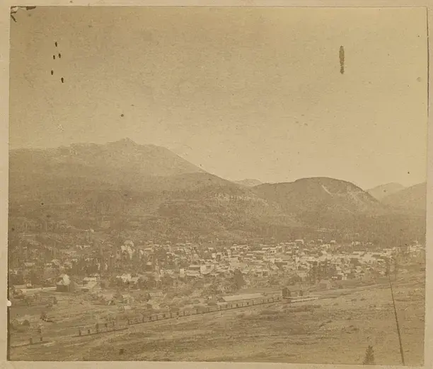
Breckenridge Colo, from Shockhill, looking west: View from Shock Hill looking east over the town of Breckenridge, Colorado towards Bald Mountain. The Denver South Park and Pacific (DSP&P) railway tracks and train depot are in the foreground, west of town. Title quoted from handwritten caption on card mount: “Breckenridge Colo, from Shockhill, looking west.” Original creator: circa 1880s-1903 (Creation); Westerman, Otto. J. Frank Willis Photograph Album. Breckenridge History, Colorado.
Harry and Nellie Rogers at Brooks-Snider Mill on Shock Hill, west of Breckenridge: The Brooks-Snider Mill on the north side of Shock Hill west of Breckenridge, Colorado. Circa 1890s. Henry (Harry) and his wife Nellie Rogers stand near a small pond. Three men sit or stand nearby. One man is smoking a pipe. Huge piles of logs are stacked outside the extensive mill operations, and a small log cabin sits at the base of the hill. Original creator: Circa 1890s; Ward, PJ. Summit Historical Society Collection. Image created by Breckenridge History, Colorado.
Nellie Rogers outside the boardinghouse at Brooks-Snider Mine on Shock Hill, west of Breckenridge: The boarding house at Brooks-Snider Mine on Shock Hill, west of Breckenridge, Colorado. Circa 1890s. Constructed of board and batten with side gables, the building has three front entry doors and several windows. A tall smokestack rises from the small wood addition. A woman, Nellie Rogers, stands next to a chair placed outside one of the doorways. Two men stand nearby. Fallen and dead trees cover the steep hillside behind them. Original creator: Circa 1890s; Ward, PJ. Summit Historical Society Collection. Image created by Breckenridge History, Colorado.
View of Breckenridge, looking east from Shock Hill: Detailed view of Breckenridge, Colorado, looking east from Shock Hill. In the lower foreground is the Denver South Park and Pacific (DSP&P) railway depot. Bald Mountain and Barney Ford Hill in the background. Original creator: Unknown; Unidentified. Summit Historical Society Collection. Image created by Breckenridge History, Colorado.
A modern touch
At Wedgewood Lodge, we want to give you a distinctive look into the past history of Breckenridge. Each photo in your historical gallery is unique to your stay and took countless hours to curate. There are stories to tell about Breckenridge and Summit County today as well, and the following photos have been shot by Julia Anna Moore.
Winter 2010
From aerial imagery, you can see the vast expanse of the White River National Forest. Can you point out Breckenridge and Copper Mountain?
From aerial imagery, you can see the vast expanse of the White River National Forest. Can you point out Breckenridge and Copper Mountain?
Summer 2020
In the midst of the pandemic, historic wildfires hit the state of Colorado. Most of my photos during my short walk on Boreas Pass had a hazy red undertone, representative of how my lungs felt even just going a short distance. The air quality was terrible, I’m surprised you could even see these mountains at all.
Duo of the Colorado Rockies framed by Evergreens. You can see the haziness as these photos were taken during the historic 2020 wildfires.
Duo of the Colorado Rockies framed by Evergreens. You can see the haziness as these photos were taken during the historic 2020 wildfires.
More hazy photos of the landscape on fire.
More hazy photos of the landscape on fire.
More hazy photos of the landscape on fire.
More hazy photos of the landscape on fire.
More hazy photos of the landscape on fire.
Summer 2022
Storms in Summit County roll in like clock work during the summertime, so you better do all your fun outdoor activities before lunch. Sometimes the rain blows over quickly, sometimes it lasts until sunset, creating a beautiful pattern in the sky.
The sun sets in July after a thunderstorm kissing Bald Mountain with alpenglow.
The sun sets in July after a thunderstorm kissing Bald Mountain with alpenglow.
The sun sets in July after a thunderstorm kissing Bald Mountain with alpenglow.
The mountains below are some of the same mountains you saw in some of my above photos from the 2020 wildfires. Notice the clarity in the air as the sun sets, lighting the mountains up with alpenglow. 2022 was a very wet year, a large contrast from the year of COVID-19.
A panoramic view of the White River National Forest.
Autumn 2022
A small snowstorm turned the peaks white in September, and I ran out of my front door to get the clouds leaving the mountains as the sky cleared. The excitement of ski season set in.
The first snowfall in September, the aspens on Peak 8 already ready to drop their leaves for wintertime.
The first snowfall in September, the aspens on Peak 8 already ready to drop their leaves for wintertime.
The first snowfall in September, the aspens on Peak 8 already ready to drop their leaves for wintertime.
Winter 2022
The picturesque Hoosier Pass in dark greens and grays as snow falls, creating yet another perfect powder day for Summit County.
A hazy snowstorm blows over the mountains, creating the atmosphere of cozying up at home with a cup of tea.
A hazy snowstorm blows over the mountains, creating the atmosphere of cozying up at home with a cup of tea.
Winter 2023
A fluffy snow had fallen all day, and as the sky cleared up in time for sunset. The alpenglow lit up the mountains before the sun sank behind the mountains creating a hazy blanket of darkness over White River National Forest.
Loveland Pass is the perfect place to take in the view, just be sure that you have 4WD if it’s been snowing and park off the road in the parking lot.
A hazy sunset paints over Loveland Pass
Strings of alpenglow touch the Pali Lift at Arapahoe Basin
Strings of alpenglow touch the Continental Divide
The alpenglow disappears and the blanket of darkness settles.
During the storm you see below in Summit, conditions were windy, rough, and cold. While most people chose to stay in, I ran up the mountain with my camera.
Imperial Express Chair during a white out at Breckenridge.
Want to take a piece of Summit County home with you? We will ship any of the prints from Julia’s gallery straight to your house. We offer different sizes and framing options. Reach out here.
.png)