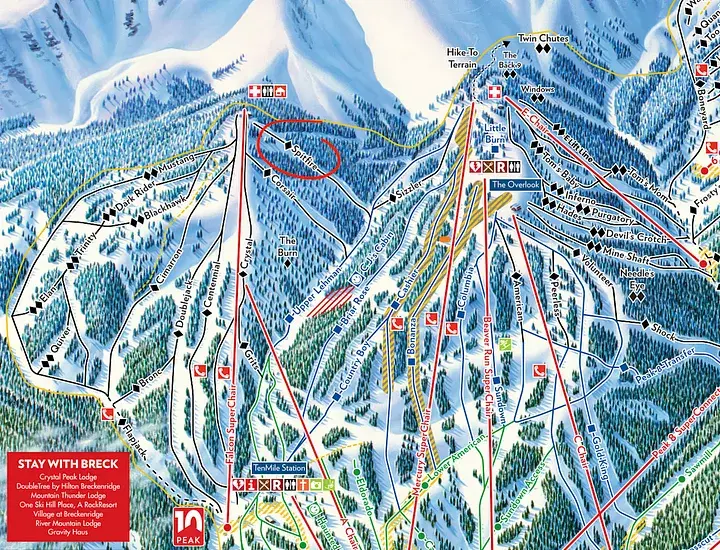
CJ’s Cabin is a really fun glade area on Peak 9 for kids and adults alike who are feeling adventurous. It gets a lot of sun, so it can get a little melted, but you can do pretty big turns in between the trees. It’s a harder blue, only because there are trees, but is a good step up for those trying to learn tree skiing on a little more difficult terrain. I couldn’t find exactly how CJ’s was named but a long time local and Olympian CJ Muller helped with naming loads of runs in the earlier days of Breck, so I’m assuming that CJ’s was named after him. This tree run is best accessed by staying left on Upper Lehman and turning onto the catwalk before dropping the trees to the right. The trees start off tight, so take it easy until it opens up, and be on the lookout for the secret cabin.
Map of Breckenridge’s Peak 9
Ten Mile Range
The Ten Mile Range, recently protected as a National Monument by President Joe Biden, softly undulates along Breckenridge’s western horizon, marking the Upper Blue River Valley boundary. Iconic Peak 8 towers above Breckenridge, related to the Matterhorn in Switzerland or Mount Rainier in Washington state. Early explorers like Rufus Sage and prospectors during the Pikes Peak gold rush mapped the region, noting its significant yet mysterious terrain. Historic maps and accounts from the 19th and early 20th centuries highlight the peaks’ names and the area’s mining history. Despite few mining claims along its eastern face, the range largely retains its historic appearance, now preserved for its cultural, historical, and natural resources, including the training grounds of the 10th Mountain Division and its significance to Native American tribes.
Ten Mile Peaks from Dillon: View of snow covered Tenmile Peaks with possibly the Snake River and Colorado & Southern railroad tracks, Dillon, Summit County, Colorado. Original creator: [1882–1890]; Jackson, William Henry, 1843–1942. Denver Public Library Special Collections, WHJ-536.
The Washington mine, showing ten mile Range: The Washington Mine near Breckenridge, Colorado, with the Tenmile Range in the background. Original creator: circa 1880s-1903 (Creation); J. Frank Willis Photograph Album. Breckenridge History, Colorado. J. Frank Willis Photograph Album. Breckenridge History, Colorado
Ten Mile Range from Rocky Point: View of snow covered river basin with Tenmile Range and mountains from Rocky Point, Summit County, Colorado. Original creator: [1882–1900?]; Jackson, William Henry, 1843–1942. Denver Public Library Special Collections, WHJ-538.
Ten Mile Peaks. Blue River valley: View of shallow bed of Blue River with Tenmile Peaks and one-story log building, Summit County, Colorado. Original creator: [1882–1900?]; Jackson, William Henry, 1843–1942. Denver Public Library Special Collections, WHJ-534.
View of Ten Mile Range from Ore Bucket Lodge, Breckenridge: View from Ore Bucket Lodge over Breckenridge residences, Summit County, Colorado, shows the Ten Mile Range in the distance under cloudy skies. Original creator: [1940–1966]; Wolle, Muriel Sibell, 1898–1977. Denver Public Library Special Collections, X-5552.
Breckenridge, Colo: View of Breckenridge (Summit County), Colorado. Shows the schoolhouse, the belfry of the Fireman’s Hall, the Denver Hotel, and the Arlington House, a frame building with a curvelinear false front and a wide cornice. The Methodist Church and the Ware-Carpenter Concentrator sheds are on the rise to west; behind them are deforested land and the Ten Mile Range. Original creator: [1892–1895?]; Westerman, Otto. Denver Public Library Special Collections, Z-1866.
A modern touch
At Wedgewood Lodge, we want to give you a distinctive look into the past history of Breckenridge. Each photo in your historical gallery is unique to your stay and took countless hours to curate. There are stories to tell about Breckenridge and Summit County today as well, and the following photos have been shot by Julia Anna Moore.
Winter 2010
From aerial imagery, you can see the vast expanse of the White River National Forest. Can you point out Breckenridge and Copper Mountain?
From aerial imagery, you can see the vast expanse of the White River National Forest. Can you point out Breckenridge and Copper Mountain?
Summer 2020
In the midst of the pandemic, historic wildfires hit the state of Colorado. Most of my photos during my short walk on Boreas Pass had a hazy red undertone, representative of how my lungs felt even just going a short distance. The air quality was terrible, I’m surprised you could even see these mountains at all.
Duo of the Colorado Rockies framed by Evergreens. You can see the haziness as these photos were taken during the historic 2020 wildfires.
Duo of the Colorado Rockies framed by Evergreens. You can see the haziness as these photos were taken during the historic 2020 wildfires.
More hazy photos of the landscape on fire.
More hazy photos of the landscape on fire.
More hazy photos of the landscape on fire.
More hazy photos of the landscape on fire.
More hazy photos of the landscape on fire.
Summer 2022
Storms in Summit County roll in like clock work during the summertime, so you better do all your fun outdoor activities before lunch. Sometimes the rain blows over quickly, sometimes it lasts until sunset, creating a beautiful pattern in the sky.
The sun sets in July after a thunderstorm kissing Bald Mountain with alpenglow.
The sun sets in July after a thunderstorm kissing Bald Mountain with alpenglow.
The sun sets in July after a thunderstorm kissing Bald Mountain with alpenglow.
The mountains below are some of the same mountains you saw in some of my above photos from the 2020 wildfires. Notice the clarity in the air as the sun sets, lighting the mountains up with alpenglow. 2022 was a very wet year, a large contrast from the year of COVID-19.
A panoramic view of the White River National Forest.
Autumn 2022
A small snowstorm turned the peaks white in September, and I ran out of my front door to get the clouds leaving the mountains as the sky cleared. The excitement of ski season set in.
The first snowfall in September, the aspens on Peak 8 already ready to drop their leaves for wintertime.
The first snowfall in September, the aspens on Peak 8 already ready to drop their leaves for wintertime.
The first snowfall in September, the aspens on Peak 8 already ready to drop their leaves for wintertime.
Winter 2022
The picturesque Hoosier Pass in dark greens and grays as snow falls, creating yet another perfect powder day for Summit County.
A hazy snowstorm blows over the mountains, creating the atmosphere of cozying up at home with a cup of tea.
A hazy snowstorm blows over the mountains, creating the atmosphere of cozying up at home with a cup of tea.
Winter 2023
A fluffy snow had fallen all day, and as the sky cleared up in time for sunset. The alpenglow lit up the mountains before the sun sank behind the mountains creating a hazy blanket of darkness over White River National Forest.
Loveland Pass is the perfect place to take in the view, just be sure that you have 4WD if it’s been snowing and park off the road in the parking lot.
A hazy sunset paints over Loveland Pass
Strings of alpenglow touch the Pali Lift at Arapahoe Basin
Strings of alpenglow touch the Continental Divide
The alpenglow disappears and the blanket of darkness settles.
During the storm you see below in Summit, conditions were windy, rough, and cold. While most people chose to stay in, I ran up the mountain with my camera.
Imperial Express Chair during a white out at Breckenridge.
Want to take a piece of Summit County home with you? We will ship any of the prints from Julia’s gallery straight to your house. We offer different sizes and framing options. Reach out here.
Sanctuary is an experts only run in between Peak 6 and Peak 7, and is honestly accessible from either side. Check the groom report before going out because these runs are typically opened later in the season. Technically on Peak 6, Sanctuary was named by public suggestions from Breckenridge fans that related to the theme of “Awaken Your Sixth Sense.” This trail was by Katie Gallagher from Denver.
Map of Breckenridge’s Peak 6
Bringing people together with dance
Before there was Breckenridge there were the Núu-agha-tʉvʉ-pʉ peoples (Ute Mountain Ute Tribe), one of the three recognized Ute tribes, along with neighboring Navajo Nation and Southern Ute Tribe. As the Ute people expanded across the Great Basin, they were connected to each other by the Southern Numic language, a division of the Uto-Aztecan language family.
Much of what we know about Colorado today is due to the knowledge of the indigenous people of the area. The mountains you see today, called the “Shining Mountains,” were home to the native Ute people for more than 8,000 years and is one of the few tribes without a migration story. The state of Utah was named after the Ute tribe, who migrated seasonally through the Rockies, following game such as bison and searching for plants to harvest. One of the infamous Colorado trees, lodgepole pines, were used to make poles for their lodges, hence “lodgepole.” They were known throughout history to be excellent horsemen and friendly to settlers in Colorado, but were driven out due to pollution in the Blue River that decreased the game in the area. Dredging of the area for the mining industry caused the pollution, leading naturalist Edwin Carter to think that it was driving species to the brink of extinction.
There is very limited photographic evidence available (at least in public archives) of Ute presence in Breckenridge due to the destruction of land and overall decline in flora and fauna by the time the camera was invented. There is also sometimes uncertainty which of the exact Ute tribes the photo represents. Many of the photos you’ll see in this gallery are of their homes from other parts of Colorado, but it’s still important to highlight the tribes existence in this area. You can read more about the Ute Tribe here and here. This unit focuses on their tradition of dance. You can watch 2023’s Bear Dance video here.
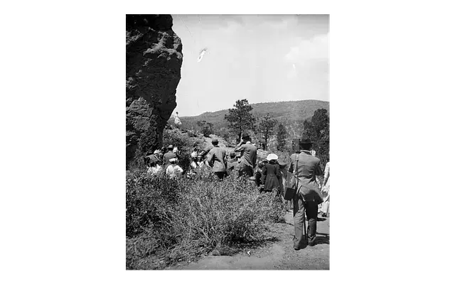
Moon dance in Garden of the Gods: Spectators look on as Native American (Ute) men participate in a Moon Dance at Garden of the Gods, El Paso County, Colorado. The Native American men wear feather headdresses. Some spectators wear hats, others hold cameras. Original creator: August 3, 1911; Poley, H. S. (Horace Swartley). Denver Public Library Special Collections, P-1308.
Moon dance in Garden of the Gods: Native American (Ute) men, women, and children participate in a Moon Dance, near The Gateway rock formation at Garden of the Gods, El Paso County, Colorado. Men wear feather headdresses. Women wear blanket shawls. Some women wear hats. Spectators stand nearby, some under umbrellas. Original creator: August 3, 1911; Poley, H. S. (Horace Swartley). Denver Public Library Special Collections, P-1304.
Moon dance in Garden of the Gods: Native American (Ute) men, women, and children participate in a Moon Dance near The Gateway rock formation at Garden of the Gods, El Paso County, Colorado. Men and boys wear feather headdresses. Women wear dresses and fringed shawls. One woman wears a metal concha belt, a shirt decorated with small shells, and a wide-brimmed hat. Spectators sit and stand and some hold umbrellas. Original creator: August 3, 1911; Poley, H. S. (Horace Swartley). Denver Public Library Special Collections, P-1307.
Moon dance in Garden of the Gods: Native American (Ute) women and white men walk on a path near the Three Graces rock formation at Garden of the Gods, El Paso County, Colorado. The women wear dresses and blanket shawls. The men wear suits and hats. The Three Graces stand in the distance. Original creator: August 3, 1911; Poley, H. S. (Horace Swartley). Denver Public Library Special Collections, P-1309.
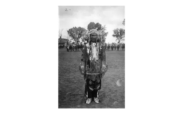
John Duncan in dancing costume: Standing portrait of John Duncan, a Native American man (Ute), wearing necklaces, a horn headdress, and beaded gloves, buckskin shirt, leggings, breechcloth, and moccasins. Original creator: 1933; Thome.. Denver Public Library Special Collections, X-30466.
Indians, Utes, dances: Native American Ute men dance wearing feather headdresses, kilts, bustles, moccasins, trousers and shirts. Original creator: [1920–1930?]; Dunning, Harold M. Denver Public Library Special Collections, X-30654.
A modern touch
At Wedgewood Lodge, we want to give you a distinctive look into the past history of Breckenridge. Each photo in your historical gallery is unique to your stay and took countless hours to curate. There are stories to tell about Breckenridge and Summit County today as well, and the following photos have been shot by Julia Anna Moore.
Winter 2010
From aerial imagery, you can see the vast expanse of the White River National Forest. Can you point out Breckenridge and Copper Mountain?
From aerial imagery, you can see the vast expanse of the White River National Forest. Can you point out Breckenridge and Copper Mountain?
Summer 2020
In the midst of the pandemic, historic wildfires hit the state of Colorado. Most of my photos during my short walk on Boreas Pass had a hazy red undertone, representative of how my lungs felt even just going a short distance. The air quality was terrible, I’m surprised you could even see these mountains at all.
Duo of the Colorado Rockies framed by Evergreens. You can see the haziness as these photos were taken during the historic 2020 wildfires.
Duo of the Colorado Rockies framed by Evergreens. You can see the haziness as these photos were taken during the historic 2020 wildfires.
More hazy photos of the landscape on fire.
More hazy photos of the landscape on fire.
More hazy photos of the landscape on fire.
More hazy photos of the landscape on fire.
More hazy photos of the landscape on fire.
Summer 2022
Storms in Summit County roll in like clock work during the summertime, so you better do all your fun outdoor activities before lunch. Sometimes the rain blows over quickly, sometimes it lasts until sunset, creating a beautiful pattern in the sky.
The sun sets in July after a thunderstorm kissing Bald Mountain with alpenglow.
The sun sets in July after a thunderstorm kissing Bald Mountain with alpenglow.
The sun sets in July after a thunderstorm kissing Bald Mountain with alpenglow.
The mountains below are some of the same mountains you saw in some of my above photos from the 2020 wildfires. Notice the clarity in the air as the sun sets, lighting the mountains up with alpenglow. 2022 was a very wet year, a large contrast from the year of COVID-19.
A panoramic view of the White River National Forest.
Autumn 2022
A small snowstorm turned the peaks white in September, and I ran out of my front door to get the clouds leaving the mountains as the sky cleared. The excitement of ski season set in.
The first snowfall in September, the aspens on Peak 8 already ready to drop their leaves for wintertime.
The first snowfall in September, the aspens on Peak 8 already ready to drop their leaves for wintertime.
The first snowfall in September, the aspens on Peak 8 already ready to drop their leaves for wintertime.
Winter 2022
The picturesque Hoosier Pass in dark greens and grays as snow falls, creating yet another perfect powder day for Summit County.
A hazy snowstorm blows over the mountains, creating the atmosphere of cozying up at home with a cup of tea.
A hazy snowstorm blows over the mountains, creating the atmosphere of cozying up at home with a cup of tea.
Winter 2023
A fluffy snow had fallen all day, and as the sky cleared up in time for sunset. The alpenglow lit up the mountains before the sun sank behind the mountains creating a hazy blanket of darkness over White River National Forest.
Loveland Pass is the perfect place to take in the view, just be sure that you have 4WD if it’s been snowing and park off the road in the parking lot.
A hazy sunset paints over Loveland Pass
Strings of alpenglow touch the Pali Lift at Arapahoe Basin
Strings of alpenglow touch the Continental Divide
The alpenglow disappears and the blanket of darkness settles.
During the storm you see below in Summit, conditions were windy, rough, and cold. While most people chose to stay in, I ran up the mountain with my camera.
Imperial Express Chair during a white out at Breckenridge.
Want to take a piece of Summit County home with you? We will ship any of the prints from Julia’s gallery straight to your house. We offer different sizes and framing options. Reach out here.
There is an aviation theme to many of the trails on Peak 10, named by former Breck ski patroller and mountain manager who had served in the Air Force. Jim Gill was responsible for naming the trails in 1985 such as Spitfire, Blackhawk, Mustang, Falcon, and Corsair after various famous aircrafts which he was familiar with. Spitfire is a fun tree run at the edge of Peak 10 that throws you out on Upper Lehman. It’s a single black diamond but with the moguls, it’s a leg burner. We recommend that only advanced skiers attempt Peak 10.
Map of Breckenridge’s Peak 9 and 10
After the war
Much of the 10th Mountain Division got into outdoor sports after they left the military, setting the foundation for the outdoor industry as we know it today. While Jim Gill wasn’t in the 10th Mountain Division, I find this as a perfect opportunity to tie in what happened to some folks after World War II. Many soldiers had fallen, many returned to life as a civilian, and some couldn’t let go of their love for the mountains. The 10th Mountain Division still exists today. Read more here.
En route to Arapahoe Basin with 10th Mtn “boys”: 10th Mountain Division veterans pose in front of a bus. Original creator: May 29, 1959; Moscow, Lorraine. 10th Mountain Division Resource Center, Denver Public Library, TMD351–2017–440.
Seven men on skis pose on flat, snowy area: From left: Howard Lent (86-M), Greenleaf Pickard (86-L), Marcus Tool (86-E), Robert Mahony (86-L), Peter Condliffe (86-L), Curt Krieser (86-L), Miller (Gordon, Robert or William?). Original creator: 1943–1944; Krear, H. Robert, 1922–2017. 10th Mountain Division Resource Center, Denver Public Library, TMD351–2017–768.
Skitrooper in woods, Colorado: Tenth Mountain Division skitrooper cross-country skiing through pines trees, Colorado. Original creator: [1943–1944]; Southworth, William A., 1921–2003. 10th Mountain Division Resource Center, Denver Public Library, TMD-732.
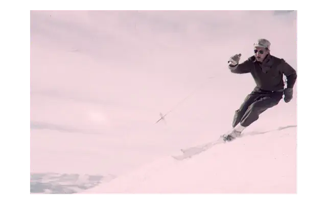
Skitrooper skiing: Tenth Mountain Division skitrooper skiing, with snowy mountains in the distance. He is wearing the woollen ski uniform and sunglasses. Original creator: [1943–1944]; Southworth, William A., 1921–2003. 10th Mountain Division Resource Center, Denver Public Library, TMD-741.
Executing a slalom turn: An unidentified skier executes a ski turn around a slalom flag during a 10th Mountain Division race. Original creator: Jan 1944; Unidentified. 10th Mountain Division Resource Center, Denver Public Library, TMD351–2020–616.
Ski shop in Colorado area: Five men (George C. Gagnon (10th Recon) second from right) are in a ski production shop with skis lying on adjustment tables and lined against the wall. Original creator: 1943–1944; Lafferty, Ralph Frederick, 1918–2012. 10th Mountain Division Resource Center, Denver Public Library, TMD351–2017–481.
A modern touch
At Wedgewood Lodge, we want to give you a distinctive look into the past history of Breckenridge. Each photo in your historical gallery is unique to your stay and took countless hours to curate. There are stories to tell about Breckenridge and Summit County today as well, and the following photos have been shot by Julia Anna Moore.
Winter 2010
From aerial imagery, you can see the vast expanse of the White River National Forest. Can you point out Breckenridge and Copper Mountain?
From aerial imagery, you can see the vast expanse of the White River National Forest. Can you point out Breckenridge and Copper Mountain?
Summer 2020
In the midst of the pandemic, historic wildfires hit the state of Colorado. Most of my photos during my short walk on Boreas Pass had a hazy red undertone, representative of how my lungs felt even just going a short distance. The air quality was terrible, I’m surprised you could even see these mountains at all.
Duo of the Colorado Rockies framed by Evergreens. You can see the haziness as these photos were taken during the historic 2020 wildfires.
Duo of the Colorado Rockies framed by Evergreens. You can see the haziness as these photos were taken during the historic 2020 wildfires.
More hazy photos of the landscape on fire.
More hazy photos of the landscape on fire.
More hazy photos of the landscape on fire.
More hazy photos of the landscape on fire.
More hazy photos of the landscape on fire.
Summer 2022
Storms in Summit County roll in like clock work during the summertime, so you better do all your fun outdoor activities before lunch. Sometimes the rain blows over quickly, sometimes it lasts until sunset, creating a beautiful pattern in the sky.
The sun sets in July after a thunderstorm kissing Bald Mountain with alpenglow.
The sun sets in July after a thunderstorm kissing Bald Mountain with alpenglow.
The sun sets in July after a thunderstorm kissing Bald Mountain with alpenglow.
The mountains below are some of the same mountains you saw in some of my above photos from the 2020 wildfires. Notice the clarity in the air as the sun sets, lighting the mountains up with alpenglow. 2022 was a very wet year, a large contrast from the year of COVID-19.
A panoramic view of the White River National Forest.
Autumn 2022
A small snowstorm turned the peaks white in September, and I ran out of my front door to get the clouds leaving the mountains as the sky cleared. The excitement of ski season set in.
The first snowfall in September, the aspens on Peak 8 already ready to drop their leaves for wintertime.
The first snowfall in September, the aspens on Peak 8 already ready to drop their leaves for wintertime.
The first snowfall in September, the aspens on Peak 8 already ready to drop their leaves for wintertime.
Winter 2022
The picturesque Hoosier Pass in dark greens and grays as snow falls, creating yet another perfect powder day for Summit County.
A hazy snowstorm blows over the mountains, creating the atmosphere of cozying up at home with a cup of tea.
A hazy snowstorm blows over the mountains, creating the atmosphere of cozying up at home with a cup of tea.
Winter 2023
A fluffy snow had fallen all day, and as the sky cleared up in time for sunset. The alpenglow lit up the mountains before the sun sank behind the mountains creating a hazy blanket of darkness over White River National Forest.
Loveland Pass is the perfect place to take in the view, just be sure that you have 4WD if it’s been snowing and park off the road in the parking lot.
A hazy sunset paints over Loveland Pass
Strings of alpenglow touch the Pali Lift at Arapahoe Basin
Strings of alpenglow touch the Continental Divide
The alpenglow disappears and the blanket of darkness settles.
During the storm you see below in Summit, conditions were windy, rough, and cold. While most people chose to stay in, I ran up the mountain with my camera.
Imperial Express Chair during a white out at Breckenridge.
Want to take a piece of Summit County home with you? We will ship any of the prints from Julia’s gallery straight to your house. We offer different sizes and framing options. Reach out here.
.png)