High Anxiety is a run on Peak 8 in Breckenridge that connects Rounders and Spruce. It’s easily missed by many, but when you’re on Peak 8 next, give it a look. It’s rated a black diamond, and is named after a successful Mel Brooks film named High Anxiety. Neighboring run Goodbye Girl is also named after a 1977 film.
Map of Breckenridge’s Peak 7 and 8
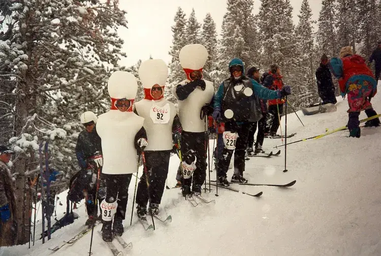
Do moguls give you anxiety?
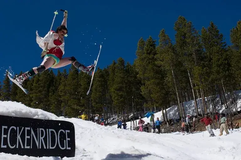
It’s alright, riding bumps are a difficult skill to acquire but with enough practice, you’ll look just as cool as these guys. The Bump Buffet was a telemarking event that was put on by Breckenridge for years, usually held on runs like Peerless and High Anxiety. With tricks, costumes, and a big crowd, the bump buffet was popular in the spring when the Colorado mountains had the highest vibes. Many of these photos were found early in the research process on telemarkskier.com but seems to be redirected to freeheellife.com now. I believe that someone bought the domain to start their telemark equipment company and now all these pictures can’t be found on the internet, therefore, I don’t know where many of these images came from or who took them. If you recognize any of these, please contact us so we can give correct credit.
A modern touch
At Wedgewood Lodge, we want to give you a distinctive look into the past history of Breckenridge. Each photo in your historical gallery is unique to your stay and took countless hours to curate. There are stories to tell about Breckenridge and Summit County today as well, and the following photos have been shot by Julia Anna Moore.
Winter 2010
From aerial imagery, you can see the vast expanse of the White River National Forest. Can you point out Breckenridge and Copper Mountain?
From aerial imagery, you can see the vast expanse of the White River National Forest. Can you point out Breckenridge and Copper Mountain?
Summer 2020
In the midst of the pandemic, historic wildfires hit the state of Colorado. Most of my photos during my short walk on Boreas Pass had a hazy red undertone, representative of how my lungs felt even just going a short distance. The air quality was terrible, I’m surprised you could even see these mountains at all.
Duo of the Colorado Rockies framed by Evergreens. You can see the haziness as these photos were taken during the historic 2020 wildfires.
Duo of the Colorado Rockies framed by Evergreens. You can see the haziness as these photos were taken during the historic 2020 wildfires.
More hazy photos of the landscape on fire.
More hazy photos of the landscape on fire.
More hazy photos of the landscape on fire.
More hazy photos of the landscape on fire.
More hazy photos of the landscape on fire.
Summer 2022
Storms in Summit County roll in like clock work during the summertime, so you better do all your fun outdoor activities before lunch. Sometimes the rain blows over quickly, sometimes it lasts until sunset, creating a beautiful pattern in the sky.
The sun sets in July after a thunderstorm kissing Bald Mountain with alpenglow.
The sun sets in July after a thunderstorm kissing Bald Mountain with alpenglow.
The sun sets in July after a thunderstorm kissing Bald Mountain with alpenglow.
The mountains below are some of the same mountains you saw in some of my above photos from the 2020 wildfires. Notice the clarity in the air as the sun sets, lighting the mountains up with alpenglow. 2022 was a very wet year, a large contrast from the year of COVID-19.
A panoramic view of the White River National Forest.
Autumn 2022
A small snowstorm turned the peaks white in September, and I ran out of my front door to get the clouds leaving the mountains as the sky cleared. The excitement of ski season set in.
The first snowfall in September, the aspens on Peak 8 already ready to drop their leaves for wintertime.
The first snowfall in September, the aspens on Peak 8 already ready to drop their leaves for wintertime.
The first snowfall in September, the aspens on Peak 8 already ready to drop their leaves for wintertime.
Winter 2022
The picturesque Hoosier Pass in dark greens and grays as snow falls, creating yet another perfect powder day for Summit County.
A hazy snowstorm blows over the mountains, creating the atmosphere of cozying up at home with a cup of tea.
A hazy snowstorm blows over the mountains, creating the atmosphere of cozying up at home with a cup of tea.
Winter 2023
A fluffy snow had fallen all day, and as the sky cleared up in time for sunset. The alpenglow lit up the mountains before the sun sank behind the mountains creating a hazy blanket of darkness over White River National Forest.
Loveland Pass is the perfect place to take in the view, just be sure that you have 4WD if it’s been snowing and park off the road in the parking lot.
A hazy sunset paints over Loveland Pass
Strings of alpenglow touch the Pali Lift at Arapahoe Basin
Strings of alpenglow touch the Continental Divide
The alpenglow disappears and the blanket of darkness settles.
During the storm you see below in Summit, conditions were windy, rough, and cold. While most people chose to stay in, I ran up the mountain with my camera.
Imperial Express Chair during a white out at Breckenridge.
Want to take a piece of Summit County home with you? We will ship any of the prints from Julia’s gallery straight to your house. We offer different sizes and framing options. Reach out here.
Crosscut is a blue run underneath Snowflake lift (which is in our backyard) that is important to note. If you want to go to the mid-load station, you have to look for the trail in the woods that is on lookers-left. If you want to continue to Peak 9, you go straight and keep your speed because it’s pretty flat and difficult for most people. I don’t think Crosscut is named after anything specific, but is more of a functional name. Right after you pass C-Chair, there is another run named Snowflake that is on lookers-left, that will take you straight home to the base of Snowflake Chair.
Map of Breckenridge’s Peak 8
Loveland Pass
Loveland Pass is kind of like the crosscut for Summit County. Before there was the Eisenhower Tunnel, there was Loveland Pass. Loveland Pass and the city of Loveland are named after William A.H. Loveland, the president of the Colorado Central Railroad. In 1869, Loveland opened a wagon road connecting Denver with Leadville, which became part of the U.S. Highway system in 1919 and served as the main route from Denver to Georgetown until the Eisenhower Tunnel opened in 1973. Located along the Continental Divide, about 70 miles east of Denver, Loveland Pass reaches an elevation of 11,991 feet and has a gnarly 6.7% grade. It serves as an alternate route for trucks carrying hazardous materials and offers scenic mountain views. While it remains open year-round, the pass can be dangerous in winter and may close temporarily during snowstorms. Please check with Colorado Department of Transportation before heading out into difficult weather.
Car On U.S. Highway 6 (Loveland Pass), 1954: One b/w photograph and negative of a car driving on U.S. Highway 6 (Loveland Pass). There is a sign on the side of the road indicating the direction and mileage to Denver and Dillion. Original creator: 1954; Ringquist, Loey. Aspen Historical Society, Ringquist Collection.
Bus ride from Denver to Aspen, 1966: One b/w negative looking towards the summit of Loveland Pass (coming from the east side), 1966-. This was the route of I-70 at the time since Eisenhower Tunnel was not built until 1973. The photo was taken from inside of a bus that was transporting passengers from Denver to Aspen; they had become stranded in Denver when their flights were cancelled by inclement weather. Related images and a story are in the Aspen Illustrated News on January 5, 1967 (page 12). 35mm roll. Original creator: 1966; Hiser, Cherie Jenkins. Aspen Historical Society, Aspen Illustrated News Collection.
Motoring on the Rockies: Clear creek, on the Loveland Pass road, near Silver Plume, only adds to the enjoyment of an auto tour. Original creator: June 7, 1925; The Rocky Mountain News. Colorado Historic Newspaper Collection.
View the Colorful Loveland Pass One Of Colorado’s Finest Scenic Beauty Spots: View the Colorful Loveland Pass One Of Colorado’s Finest Scenic Beauty Spots. Original creator: December 10, 1938; The Denver Star. Colorado Historic Newspaper Collection.
Snowboarders walk into the summit of Loveland Pass during the moonlight to back country ski at night January 3, 2007. Scores of skiers gather during the full moon for an experience that is unique to Colorado’s back country: Snowboarders are at the top of their game, having reached the summit of Loveland Pass. During the previous full moon Jan. 3, skiers could be found making tracks in new snow on or around Loveland Pass, Berthoud Pass, Quandary Peak and the Indian Peaks Wilderness Area. Original creator: 2007; DENNIS SCHROEDER. Donated to the Denver Public Library by the Rocky Mountain News, RMN-032–9070.
William A. “Bill” Southworth at the Continental Divide, Loveland Pass, Colorado: Tenth Mountain Division soldier, William A. “Bill” Southworth poses for a portrait at the Continental Divide. He is wearing a khaki uniform with a white belt, which was not army issue. The signs at the side of the highway identify the place: the first is Colorado, U.S. Highway 6. Denver 62 miles east, Dillon 15 miles west. A larger sign reads Continental Divide, Loveland Pass, elevation 11,992 feet above sea-level; Atlantic Ocean watershead to the east, Pacific Ocean; watershead to the west; Clear Creek County to the east, Summit County to the west. Original creator: [1943,1944]; Southworth, William A., 1921–2003. 10th Mountain Division Resource Center, Denver Public Library.
A modern touch
At Wedgewood Lodge, we want to give you a distinctive look into the past history of Breckenridge. Each photo in your historical gallery is unique to your stay and took countless hours to curate. There are stories to tell about Breckenridge and Summit County today as well, and the following photos have been shot by Julia Anna Moore.
Winter 2010
From aerial imagery, you can see the vast expanse of the White River National Forest. Can you point out Breckenridge and Copper Mountain?
From aerial imagery, you can see the vast expanse of the White River National Forest. Can you point out Breckenridge and Copper Mountain?
Summer 2020
In the midst of the pandemic, historic wildfires hit the state of Colorado. Most of my photos during my short walk on Boreas Pass had a hazy red undertone, representative of how my lungs felt even just going a short distance. The air quality was terrible, I’m surprised you could even see these mountains at all.
Duo of the Colorado Rockies framed by Evergreens. You can see the haziness as these photos were taken during the historic 2020 wildfires.
Duo of the Colorado Rockies framed by Evergreens. You can see the haziness as these photos were taken during the historic 2020 wildfires.
More hazy photos of the landscape on fire.
More hazy photos of the landscape on fire.
More hazy photos of the landscape on fire.
More hazy photos of the landscape on fire.
More hazy photos of the landscape on fire.
Summer 2022
Storms in Summit County roll in like clock work during the summertime, so you better do all your fun outdoor activities before lunch. Sometimes the rain blows over quickly, sometimes it lasts until sunset, creating a beautiful pattern in the sky.
The sun sets in July after a thunderstorm kissing Bald Mountain with alpenglow.
The sun sets in July after a thunderstorm kissing Bald Mountain with alpenglow.
The sun sets in July after a thunderstorm kissing Bald Mountain with alpenglow.
The mountains below are some of the same mountains you saw in some of my above photos from the 2020 wildfires. Notice the clarity in the air as the sun sets, lighting the mountains up with alpenglow. 2022 was a very wet year, a large contrast from the year of COVID-19.
A panoramic view of the White River National Forest.
Autumn 2022
A small snowstorm turned the peaks white in September, and I ran out of my front door to get the clouds leaving the mountains as the sky cleared. The excitement of ski season set in.
The first snowfall in September, the aspens on Peak 8 already ready to drop their leaves for wintertime.
The first snowfall in September, the aspens on Peak 8 already ready to drop their leaves for wintertime.
The first snowfall in September, the aspens on Peak 8 already ready to drop their leaves for wintertime.
Winter 2022
The picturesque Hoosier Pass in dark greens and grays as snow falls, creating yet another perfect powder day for Summit County.
A hazy snowstorm blows over the mountains, creating the atmosphere of cozying up at home with a cup of tea.
A hazy snowstorm blows over the mountains, creating the atmosphere of cozying up at home with a cup of tea.
Winter 2023
A fluffy snow had fallen all day, and as the sky cleared up in time for sunset. The alpenglow lit up the mountains before the sun sank behind the mountains creating a hazy blanket of darkness over White River National Forest.
Loveland Pass is the perfect place to take in the view, just be sure that you have 4WD if it’s been snowing and park off the road in the parking lot.
A hazy sunset paints over Loveland Pass
Strings of alpenglow touch the Pali Lift at Arapahoe Basin
Strings of alpenglow touch the Continental Divide
The alpenglow disappears and the blanket of darkness settles.
During the storm you see below in Summit, conditions were windy, rough, and cold. While most people chose to stay in, I ran up the mountain with my camera.
Imperial Express Chair during a white out at Breckenridge.
Want to take a piece of Summit County home with you? We will ship any of the prints from Julia’s gallery straight to your house. We offer different sizes and framing options. Reach out here.
Tom’s Baby and Tom’s Mom are some of my favorite names of trails in Breck. This run has historical significance because it was named after the biggest gold nugget ever found in history, which I will talk about below. To honor this incredible find, this double black diamond on Peak 9 was named after… well… Tom’s Baby. I recommend that only advanced skiers go to this steep tree run which is accessed by Mercury SuperChair.
Map of Breckenridge’s Peak 9
Farncomb Hill and the big baby
On July 23, 1887, Tom Groves and Harry Lytton discovered the largest piece of gold ever found in Colorado, a 13 ½ pound nugget in the Farncomb Hill area near Breckenridge, famously known as “Tom’s Baby” after Groves wrapped it in a blanket and carried it like an infant to avoid theft. Groves paraded the massive gold nugget around Breckenridge, where it quickly became renowned. After being cleaned by an assayer, the nugget was handed to a mine owner, Ward, who sent it to Denver, where it mysteriously vanished. Around 1900, it was sought for exhibitions but remained missing until local historian Mark Fiester rediscovered it in 1972 in a Denver bank vault, mislabeled as dinosaur bones (are you kidding me?). The piece, now 10 ½ pounds, resides at the Denver Museum of Nature & Science, still stirring curiosity about the missing three pounds. Three pounds of gold today would be worth a little over $103,000 USD (as of July 2024). What do you think happened to this chunk? I guess we will never know.
View on Farncom hill: The Great Flume going around the hill opposite Mount Guyot (in background), northeast of Breckenridge, Colorado in autumn of 1895. In the snow, a man stands next to the waist-high wooden flume while a dog sits on top. Title quoted from handwritten caption on card mount: “View on Farncom [sic] hill.” Original creator: 1895 (Creation); Westerman, Otto. J. Frank Willis Photograph Album. Breckenridge History, Colorado.
The mineral resources of Summit County: View of a 156 ounce specimen of crystallized gold, known as “Tom’s Baby,” taken from the Gold Flake Mine on Farncomb Hill, near Breckenridge, Summit County, Colorado. The specimen was named after Tom Groves, one of the miners who discovered it. Formerly F24822. Penciled on back of photographic print: “The largest gold nugget [sic] ever found in Colorado — (156 ounces or 13 lbs Troy). Taken from Gold Flake Mine on Farncomb Hill, Summit Co. July 23, 1887. Known as “Tom’s Baby” for Thomas F. Walsh, owner of mine [sic]. “ [In fact, the crystallized gold specimen was discovered by two miners, Tom Groves and Harry Lytton, and allegedly named after Tom Grove’s.]; Photographic print is of half-tone reproduction. Original creator: 1899; Jas. F. Callbreath Jr.. Denver Public Library Special Collections, X-60191.
Great Flume in American Gulch on Farncomb Hill near Breckenridge: View of the Great Flume in American Gulch, located on Farncomb Hill near Breckenridge, Colorado. Circa 1896. The mill, originally built for the Victoria Gold Mining Company in 1887, is in view on the steep hillside. Original creator: Circa 1896; Unidentified. Summit Historical Society Collection. Image created by Breckenridge History, Colorado.
Actual size of a gold nugget, taken from Farncomb hill: 136-ounce mass of crystalized gold from the Gold Flake vein on Farncomb Hill called “Tom’s Baby”. Found on July 23, 1887 by Harry Lytton and Tom Groves outside of Breckenridge, Colorado. Original creator: circa 1880s-1903 (Creation); Westerman, Otto. J. Frank Willis Photograph Album. Breckenridge History, Colorado.
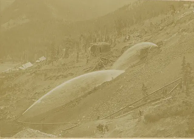
Wapiti Mining Company’s hydraulic operations in American Gulch near Breckenridge, Colorado: Wapiti Mining Company’s mining operations in American Gulch below Farncomb Hill, near Breckenridge, Colorado. An hydraulic pipe with high pressure nozzle (called a “Giant”) drives gravel from the tree-cleared hillside. The Victoria Gold Mining Company’s mill, built in 1888, is in view on the left. Original creator: Circa 1895; Westerman, Otto. Summit Historical Society Collection. Image created by Breckenridge History, Colorado.
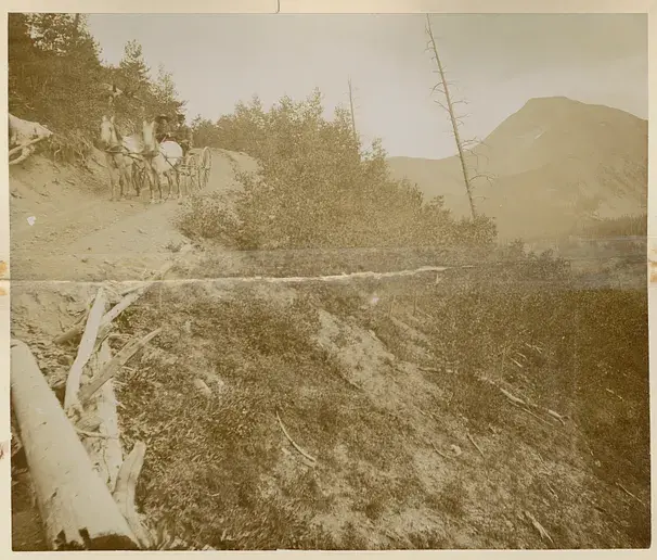
Ben Stanley Revett in a horse-drawn carriage coming down Farncomb Hill, Breckenridge: Ben Stanley Revett and another man in a two-horse drawn carriage coming down a steep dirt road on the French Gulch side of Farncomb Hill, near Breckenridge, Colorado. Mount Guyot in the background. Original creator: Circa early 1900s; Unidentified. Summit Historical Society Collection. Image created by Breckenridge History, Colorado.
A modern touch
At Wedgewood Lodge, we want to give you a distinctive look into the past history of Breckenridge. Each photo in your historical gallery is unique to your stay and took countless hours to curate. There are stories to tell about Breckenridge and Summit County today as well, and the following photos have been shot by Julia Anna Moore.
Winter 2010
From aerial imagery, you can see the vast expanse of the White River National Forest. Can you point out Breckenridge and Copper Mountain?
From aerial imagery, you can see the vast expanse of the White River National Forest. Can you point out Breckenridge and Copper Mountain?
Summer 2020
In the midst of the pandemic, historic wildfires hit the state of Colorado. Most of my photos during my short walk on Boreas Pass had a hazy red undertone, representative of how my lungs felt even just going a short distance. The air quality was terrible, I’m surprised you could even see these mountains at all.
Duo of the Colorado Rockies framed by Evergreens. You can see the haziness as these photos were taken during the historic 2020 wildfires.
Duo of the Colorado Rockies framed by Evergreens. You can see the haziness as these photos were taken during the historic 2020 wildfires.
More hazy photos of the landscape on fire.
More hazy photos of the landscape on fire.
More hazy photos of the landscape on fire.
More hazy photos of the landscape on fire.
More hazy photos of the landscape on fire.
Summer 2022
Storms in Summit County roll in like clock work during the summertime, so you better do all your fun outdoor activities before lunch. Sometimes the rain blows over quickly, sometimes it lasts until sunset, creating a beautiful pattern in the sky.
The sun sets in July after a thunderstorm kissing Bald Mountain with alpenglow.
The sun sets in July after a thunderstorm kissing Bald Mountain with alpenglow.
The sun sets in July after a thunderstorm kissing Bald Mountain with alpenglow.
The mountains below are some of the same mountains you saw in some of my above photos from the 2020 wildfires. Notice the clarity in the air as the sun sets, lighting the mountains up with alpenglow. 2022 was a very wet year, a large contrast from the year of COVID-19.
A panoramic view of the White River National Forest.
Autumn 2022
A small snowstorm turned the peaks white in September, and I ran out of my front door to get the clouds leaving the mountains as the sky cleared. The excitement of ski season set in.
The first snowfall in September, the aspens on Peak 8 already ready to drop their leaves for wintertime.
The first snowfall in September, the aspens on Peak 8 already ready to drop their leaves for wintertime.
The first snowfall in September, the aspens on Peak 8 already ready to drop their leaves for wintertime.
Winter 2022
The picturesque Hoosier Pass in dark greens and grays as snow falls, creating yet another perfect powder day for Summit County.
A hazy snowstorm blows over the mountains, creating the atmosphere of cozying up at home with a cup of tea.
A hazy snowstorm blows over the mountains, creating the atmosphere of cozying up at home with a cup of tea.
Winter 2023
A fluffy snow had fallen all day, and as the sky cleared up in time for sunset. The alpenglow lit up the mountains before the sun sank behind the mountains creating a hazy blanket of darkness over White River National Forest.
Loveland Pass is the perfect place to take in the view, just be sure that you have 4WD if it’s been snowing and park off the road in the parking lot.
A hazy sunset paints over Loveland Pass
Strings of alpenglow touch the Pali Lift at Arapahoe Basin
Strings of alpenglow touch the Continental Divide
The alpenglow disappears and the blanket of darkness settles.
During the storm you see below in Summit, conditions were windy, rough, and cold. While most people chose to stay in, I ran up the mountain with my camera.
Imperial Express Chair during a white out at Breckenridge.
Want to take a piece of Summit County home with you? We will ship any of the prints from Julia’s gallery straight to your house. We offer different sizes and framing options. Reach out here.
.png)